Geology doesn’t begin and end with the rocks. Yes, the landscape all around Moab and throughout southeastern Utah is dominated by exposed bedrock. Here, the scenery is predominantly “cliffs of rocks, tables of rock, plateaus of rock, terraces of rock, crags of rock” to quote the geologist/explorer John Wesley Powell who led the pioneering expedition down the Green and Colorado rivers in 1869.
However, the landscape isn’t all rock. Canyon country is inhabited by wildlife ranging from lizards and ground squirrels to bighorn sheep and mountain lions. Vegetation is generally sparse in the desert, but grasses, wildflowers, shrubs, and trees grow throughout the area, sometimes even gaining a toehold on bare rock surfaces.
To me, the most fascinating aspects of biota of canyon country result from the interconnections between the landscape and the life of the desert. These relationships are sometimes described as biogeography or geo-ecology. As naturalist Annie Dillard wrote in her book Teaching a Stone to Talk:
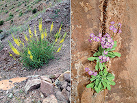
“Geography is life’s limiting factor. Speciation—life itself—is ultimately a matter of warm and cool currents, rich and bare soils, deserts and forests, fresh and salt waters, deltas and jungles and plains…life is a gloss on geography. And if you dig your fists into the earth and crumble geography, you strike geology. Climate is the wind of the mineral earth’s rondure, tilt, and orbit modified by local geologic conditions. The Pacific Ocean, the Negev Desert, and the rain forests in Brazil are local geologic conditions….It is all, God help us, a matter of rocks.” Prince’s plume (left), cave primrose (right)
Life in canyon country is also dependent on geology. The interrelationships between animals and geology, plants and geology, and human history and geology control the distribution of life here, from the larger tableau to fine details.
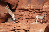
Some species of wildlife are generalists that do not have specific habitat requirements for where they live. For example, coyotes live in a range of geologic environments from deep canyons to the wide open spaces of the flat lands. On the other hand, bighorn sheep have a very specific geologic preference as their agility is an adaptation to inhabiting steep cliffs and rocky slopes, which affords them protection from predators. Even some species of lizards have geologic preferences. The tree lizard prefers to inhabit vertical surfaces, which here in canyon country are predominantly rock walls.
Vegetation is impacted by geology in many ways. Some plants require specific soils to grow or thrive. Prince’s plume, for example, grows in selenium-rich soils, which may form on specific rocks layers (formations to geologists) like the Moenkopi or Chinle Formations. Other plants take advantage of microclimates, the presence of which greatly add to the plant diversity in canyon country. Areas with cooler and/or wetter conditions may be populated by species that can only survive in
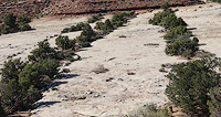
Pinyon pine, juniper trees, and shrubs growing along sets of parallel joints.
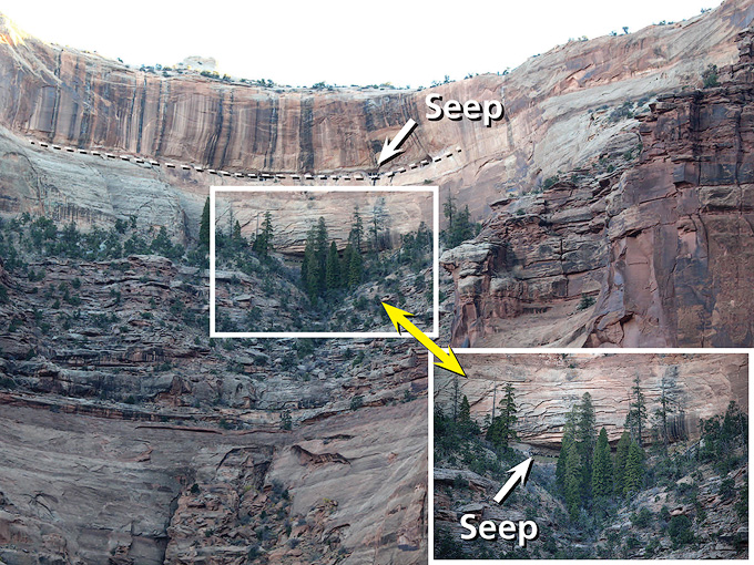
such niches. A prominent example is a north-facing slope near the canyon rim above the Shafer Trail in Canyonlands National Park that hosts a relict population of Douglas fir trees near a spring-fed alcove. Slope aspect, or the compass direction of an inclined land surface, greatly impacts soil temperature and moisture content, which in turn impacts the plant communities that live in specific areas. Plants that need more moisture like the Douglas firs can live at significantly lower elevations on north-facing slopes than otherwise.
Springs or seeps are another geologic environment that host distinct plant communities, including monkey flower, cave primrose, and maidenhair fern. Springs are places where groundwater flows onto the Earth’s surface. Although they have distinct plant communities, springs are ultimately geologic phenomena that are controlled by factors such as rock type, the presence of faults or fractures, or the occurrence of impermeable lenses in otherwise permeable rock layers that force groundwater to move laterally to emerge from the ground.
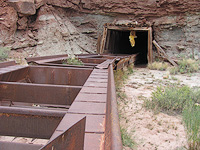
Fine geologic details also impact where plants grow. For example, joints (rock fractures) provide locales where water can concentrate and soil can accumulate so that the alignment of woody vegetation growing in them follows the trace of joint pattern. The Mi Vida uranium mine in 2014
And finally, geology shapes human lifeways. The history of any area is impacted by its geology. Settlement patterns in the Southwest are dictated by the availability of water and travel routes. The deep canyons and major cliff-forming rock layers of southeastern Utah means that modern highways like U.S. 191 follow the same routes as historic ones like the Old Spanish Trail.
In the 1950s, Moab was known as the richest town in the United States during the uranium rush when significant discoveries of uranium ore such as at the Mi Vida mine turned what had been a sleepy cattle town into a boomtown. Nowadays, even though there is some mineral and oil and gas extraction in the area, the scenic splendor of the area’s geology powers the area’s economy. People come to Moab to gaze at rocks, to mountain bike and jeep across rocks, to hike among the rocks, to climb up rocks, and float the rivers beneath rock walls. Like the Pacific Ocean, the Negev Desert, and the rain forests in Brazil, Moab is indeed a matter of rocks.
Douglas fir trees growing in a north-facing alcove in Canyonlands National Park.
A self-described “rock nerd,” Allyson Mathis is a geologist, informal geoscience educator and science writer living in Moab.
To learn more about Moab’s geology, visit the Geology Happenings archive online at https://www.moabhappenings.com/Archives/000archiveindex.htm#geology
 A self-described “rock nerd,” Allyson Mathis is a geologist, informal geoscience educator and science writer living in Moab.