Sand Flats Recreation Area - a Public Lands Treasure
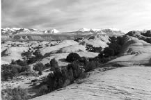 1.
What is the Sand Flats Recreation Area? The Sand Flats Recreation
Area (SFRA) near Moab, Utah is a 7,240 acre, nationally significant
public lands treasure at the heart of the Colorado Plateau. A high plane
of slickrock domes, bowls and fins, it rises on the south to meet the
colorful mesas and nearly 13,000-foot peaks of the La Sal Mountains.
Cutting into the area on the east and west are the canyons of the Negro
Bill and Mill Creek Wilderness Study Areas. To the north lies the deep
gorge of the Colorado River and a hundred mile vista over Arches National
Park. SFRA is home to the famous Slickrock Bike Trail enjoyed annually
by over 100,000 visitors. The SFRA is also popular for camping and jeeping.
1.
What is the Sand Flats Recreation Area? The Sand Flats Recreation
Area (SFRA) near Moab, Utah is a 7,240 acre, nationally significant
public lands treasure at the heart of the Colorado Plateau. A high plane
of slickrock domes, bowls and fins, it rises on the south to meet the
colorful mesas and nearly 13,000-foot peaks of the La Sal Mountains.
Cutting into the area on the east and west are the canyons of the Negro
Bill and Mill Creek Wilderness Study Areas. To the north lies the deep
gorge of the Colorado River and a hundred mile vista over Arches National
Park. SFRA is home to the famous Slickrock Bike Trail enjoyed annually
by over 100,000 visitors. The SFRA is also popular for camping and jeeping.
2. Who manages Sand Flats Recreation Area? The Sand
Flats Recreation Area is managed through a unique partnership between
Grand County and the Bureau of Land Management. This area was developed
in 1995 through the collaborative efforts of Americorps, the BLM, Grand
County and the Moab Community. You can help our partnership efforts
by taking responsibility for the lands you enjoy. Learn the guidelines
of sustainable land use by:
· Understanding how your use affects the land.
· Adopting minimum impact practices.
· Sharing in costs of services, education and maintenance.
 3.
Where do my fees go? All user fees remain in this program and
go towards services and maintenance. Information services include staffing
the entrance station, campground and backcountry patrols, displays,
brochures and maps. Maintenance includes upkeep of campgrounds, toilet
facilities and trails. Resource protection comprises upkeep of fences,
signs and revegetation projects.
3.
Where do my fees go? All user fees remain in this program and
go towards services and maintenance. Information services include staffing
the entrance station, campground and backcountry patrols, displays,
brochures and maps. Maintenance includes upkeep of campgrounds, toilet
facilities and trails. Resource protection comprises upkeep of fences,
signs and revegetation projects.
A portion of fees collected go to pay for the annual lease of this land.
Your fees also sustain an apprenticeship program that provides work-study
opportunities for local high school students. In addition a portion
of fees helps to support the operation of Grand County Search and Rescue.
4. What is the user fee at SFRA? SFRA offers day-use
passes, good for 3 days.Private vehicle passes cost $5.00, bike passes
cost $2.00, shuttle/van passes cost $2.00 per person. Annual passes
cost $20.00 and are good for day use by the cardholder and their family.
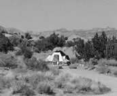
 5.
Can I camp at SFRA? Yes, Sand Flats has 107 campsites, open
year round and offered on a first-come, first-serve basis. Campsites
are spread out over 8 camp clusters (lettered A thru H) each with a
picnic table, metal fire ring and nearby vault toilet. Campers need
to bring in all their drinking water, as water is not available on this
high desert plateau. Camping at SFRA costs $8.00 per night per car for
1 to 4 people. Additional persons cost $2.00 each per night. Children
7 years and under camp for free.
5.
Can I camp at SFRA? Yes, Sand Flats has 107 campsites, open
year round and offered on a first-come, first-serve basis. Campsites
are spread out over 8 camp clusters (lettered A thru H) each with a
picnic table, metal fire ring and nearby vault toilet. Campers need
to bring in all their drinking water, as water is not available on this
high desert plateau. Camping at SFRA costs $8.00 per night per car for
1 to 4 people. Additional persons cost $2.00 each per night. Children
7 years and under camp for free.
6. Does SFRA take group site reservations? Yes, the
maximum number of occupants in a group campsite is 16. The reservation
fee is $10.00 and the base fee is $24.00. If you would like to reserve
a site please call 435-259-2444 between 8-9 am or 5-6 pm seven days
a week. Groups larger than 16 people can reserve a group campsite along
the Colorado River. Call the BLM at 435-259-2100 or visit their web
site at www.blm.gov/utah/moab.
7. What are the trail rules at Sand Flats?
Whether traveling by bike, motorcycle, ATV or 4 WD vehicle, users need
to follow these rules:
· Stay on the trail. Turn around on rock surface only.
· Do not trample vegetation or cryptobiotic crust.
· Avoid driving in potholes.
· Respect all living things.
· Pack it in. Pack it out.
· Responsible use keeps this trail clean, scenic and OPEN.
 8.
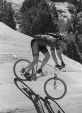
How difficult is mountain biking the Slickrock Bike trail?
The Slickrock Bike trail is rated a class 4 on a scale of 1-4, 4 being
the hardest. Steep inclines and descents offer technical challenges
to the most experienced bikers. The 2.3 mile Practice Loop is recommended
to first time visitors and takes about a half hour. The Practice Loop
is still rated as difficult and not for children, novice riders or out-of-shape
individuals. The main trail is 12.7 miles and takes about 3-4 hours
to complete. The biking season is mid-February through November, but
the trail is most popular during spring and fall. If you must ride during
the summer plan a 6 am start to avoid potentially life threatening heat.
8.
How difficult is mountain biking the Slickrock Bike trail?
The Slickrock Bike trail is rated a class 4 on a scale of 1-4, 4 being
the hardest. Steep inclines and descents offer technical challenges
to the most experienced bikers. The 2.3 mile Practice Loop is recommended
to first time visitors and takes about a half hour. The Practice Loop
is still rated as difficult and not for children, novice riders or out-of-shape
individuals. The main trail is 12.7 miles and takes about 3-4 hours
to complete. The biking season is mid-February through November, but
the trail is most popular during spring and fall. If you must ride during
the summer plan a 6 am start to avoid potentially life threatening heat.
9. What is the Porcupine Rim Trail like? The “other
mountain biking trail” at SFRA is the Porcupine Rim Trail, popular
and difficult (class 4). The trailhead is located on the eastern end
of SFRA, 7 miles up the Sand Flats road from the entrance station. The
first part of the trail is shared with motorized users. At mile 11.2
the trail becomes single track with steep ledges and is suitable only
for biking and hiking. The trail is usually ridden one way and takes
3 hours to half a day. From the trailhead to highway 128 is 14.4 miles
or 20.4 miles to Moab. If ridden as a loop from town, the entire ride
is 30.8 miles. Shuttle services can provide transportation to the trailhead.
The Porcupine Rim trail offers a variety of riding surfaces in a remote
and rugged area of outstanding scenery.
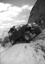
10. Does Sand Flats have motorized trails? Yes. SFRA
has over 40 miles of jeep trails that motorcycles and all-terrain vehicles
(ATVs) are also welcome to ride. These include Fins ‘n’
Things Jeep Trail, Porcupine Jeep Trail, Hell’s Revenge Trail
and the first 11.2 miles of the Porcupine Rim Trail. Motorcycles may
ride the Slickrock Bike Trail but it is not suitable for ATVs due to
steep side slopes and narrow ledges. All users (motorized and non-motorized)
must travel marked routes. There are NO open play areas in Sand Flats.
Motorized traffic yields to non-motorized traffic. Motorcycles and ATV’s
are responsible for following Utah State Regulations for off-highway
vehicles. For more information visit www.stateparks.utah.gov/ohv/laws.htm.
How do I “play it safe” while recreating at the
SFRA? This area offers challenging riding amidst world-class
scenery. The characteristics that make it a special place for riding
also make it extremely important to follow basic safety procedures.
The Moab Bike Patrol has this to say:
· Wear a helmet. Most trails are very rocky. Even the best riders can get tired and make mistakes. Helmets can prevent or reduce the severity of head injuries.
· Carry lots of water and high-energy food. At least a gallon of water is recommended per person per day. There is no water on the trails and summer temperatures often climb above 100 degrees Fahrenheit. Running out of water will put your health at risk. Eating at intervals provides an opportunity to rest and the energy to complete the ride.
· Carry trail maps and know how to use them. Maps for Slickrock and Porcupine Rim trails are located at the trailheads and entrance station. Maps for 4WD roads are available at the entrance station.
· Stay found, save money. Grand County has the highest incidence of search and rescue in Utah. The high cost of these operations is normally the responsibility of the rescued party. If you decide that you have lost the trail, do not continue on in hopes of finding your own way. Retrace your route back towards the trailhead until you pick up the trail, find someone who knows the area, or return to the trailhead. If you cannot retrace your route, stay put, conserve energy and water, make yourself visible and await rescue. It’s always a good idea to let a friend or relative know where you are going and when you should return. If something goes wrong you have the comfort of knowing that they will get help.
· Check your bike frequently. Riding on Moab trails loosens headsets and puts maximum stress upon frames and components. Frequent inspections reduce the possibility of injury.
· Be prepared in case of emergency. Don’t venture into remote areas with nothing but a t-shirt and shorts. Carry a windbreaker, sunscreen, sunglasses, maps, matches or lighter, pump, patch kit, first-aid kit, a good bike tool kit and extra food, water and clothing. Ride with someone else and stay together in case of problems. Discuss your situation calmly and make a plan to improve it.
What are some safety tips for traveling in the SFRA backcountry by motorized vehicle?
· Let someone know your itinerary. It’s always a good idea to let a friend or relative know where you are going and when you should return. If something goes wrong you have the comfort of knowing that they will get help.
· Travel with another vehicle. You chances of getting stuck in the backcountry are reduced with two vehicles and if one breaks down you have a way out.
· Carry trail maps and know how to use them.
Maps for Slickrock and Porcupine Rim trails are located at the trailheads and entrance station. Maps for 4WD roads are available at the entrance station. If you decide that you have lost the trail, do not continue on inhopes of finding your own way. Retrace your route back towards the trailhead until you pick up the trail.
· Changing conditions. Signs may be removed or vandalized. New roads can spring up. Use your map or guidebook but exercise common sense when discrepancies occur.
· Inspect your vehicle. Before going in the backcountry make sure that your vehicle it is in top operating condition.
· Drive or ride Safe and Sober. It is illegal in Utah for any occupant of a vehicle to drink or even open an alcoholic beverage. Please remember to buckle up.
Can I bring my dog? Yes,
SFRA is “dog friendly”. You need to keep your dog under
physical or verbal control at all times. Dogs should not chase or harass
wildlife. A good place to take your dog for a walk is to hike one of
the four-wheel drive roads such as the Fins n Things Jeep Trail. The
Slickrock Bike Trail is not recommended for dogs. Most dogs are not
used to running on sandstone, which acts like sandpaper on their paws.
Owners also need to remember to carry water for their pooch. If you
are riding the bike trail and would like to leave your dog behind, one
option is to find a vacant campsite, with shade, and leave your dog
tied up for the few hours you are on the trail. Never leave your dog
in a parked car as temperatures rise to dangerously high levels quickly
in the desert. There is also a kennel in Moab.
Does Sand Flats waive fees for volunteer groups? As
a self-sustaining program SFRA cannot afford to waive fees. Sand Flats
will, however, waive up to half of the camping fees for at least one
full day of volunteer service. This half price fee is at the discretion
of the manager. SFRA also has a volunteer service program that gives
participants an annual pass for day-use valued at $20.00. These events
are advertised in local papers and radio and usually held in the spring
and fall. The volunteer labor of local and visiting volunteers are important
contributions to operations at SFRA.
Trail map brochures are available at the entrance booth and
at the trailhead. Detailed topographic maps and guidebooks are available
in Moab at bike shops, bookstores and the Moab Information Center.
© 2002-2026 Copyright Moab Happenings. All rights reserved.
Reproduction of information contained in this site is expressly prohibited without the written permission of the publisher.