A Canyonlands Glow Up: Walking to and Basking in Mesa Arch by Kathy Grossman
On a recent trip to Tucson, Arizona, I checked into my hotel room and was greeted by a familiar triptych photograph over the bed: Mesa Arch! The Navajo sandstone reds, salmons, golds and buttery yellows were all there, backlit by a sunrise. To see the real thing, you should go to the Mesa Arch Trailhead in Canyonlands National Park. The trail is a 0.6-mile (1-kilometer) roundtrip loop with only about a 50- to 150-foot elevation gain. A “glow up” is a positive transformation in a person’s life, often involving fitness and mental well-being, The Mesa Arch Trail offers some of both.
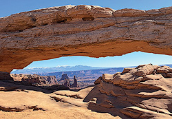
Altogether, this trailhead is about a 45-minute drive from Moab and 6.3 miles south of the Island in the Sky Visitor Center, accessed once you turn left/east into the Mesa Arch Parking Area. The trail features chunky steps, packed dirt, and slickrock. Going clockwise, about halfway up the trail (0.3 of a mile), is the 27-foot-long pothole arch rock span, named for its setting, perched on a cliff at the eastern edge of Island in the Sky Mesa, part of a 1,200-foot total drop into Buck Canyon. (There is also a short, paved Buck Canyon Overlook trail to a railed-off viewpoint south of Mesa Arch.) Looking down, you can see the White Rim Road and Mountain Bike Trail; beyond, the Colorado River meets the Green River and flows southwest down into and through the Grand Canyon. Choose your direction
Mesa Arch is popular and can be very crowded at the break of day, as photographers lie in wait for the sun’s rays to light up the underside of the arch and distant canyon features. But, unlike Hollywood paparazzi, shutterbugs won’t need to chase this star for a photo, they just have to plan around sunrise times. Because the La Sal Mountains are east-southeast of Moab, the sun appears slightly later than in the valley. In early April, sunrise at this arch will be about 7:00–7:15 a.m., by mid-April it will be 6:50–7:00 a.m., and at 6:30–6:45 a.m. by the end of the month.
Mesa provides a long slash of a window to frame the canyons below, including on both sides of the arch. You know how timid—or exuberant—your little outdoors person can be, so supervise, hang onto, or tether young ones around the arch as there is no fence. Washer Woman Arch is a 500-foot tall sandstone arch and tower off to the left through Mesa’s portal. Monster Tower, an imposing 600-foot-tall Wingate sandstone guardian, is to the right/east of Washer Woman. Stay on the trail to protect the fragile cryptobiotic soil.
To avoid the largest crowds, hike this trail several hours after sunrise (as I did) or in the late afternoon. On the morning I was there, visitors were patient, snapping photos, then stepping aside and offering to do photos for other groups. Whichever direction you choose, this may not be an “easy” hike for some. The loop has slightly more elevation change at the beginning if you travel counter-clockwise. To reduce the number of stairs, walk clockwise to the arch, then retrace your steps. The steps are chunky, and some sandstone is covered in loose sand, so trekking poles may come in handy for elderly visitors or those with mobility issues. However you enjoy the Mesa Arch setting—at dawn, after a snowfall, in the fog, at sunset, or even over a hotel room bed—bask in this glowing geological starshine in our amazing national park.
This is my last column for Moab Happenings as I leave the Colorado Plateau for the Sonoran Desert. I have enjoyed hiking and writing about a wide variety of trails on our public lands and meeting walkers from around the world. Thank you to Theresa King for this writing opportunity, the layout masters for their artistic eye, the writing group for their encouragement, and the dreamers, architects, earth movers, and volunteers who glow up our trails and trailheads.
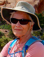
Kathy Grossman is an L.A. girl, artist, nature journalist, writer, and a fan of the inclusive kindness of Valentine’s Day. Her father worked in Hollywood and was friends with Daws Butler and Mel Blanc, Barney Rubble’s voice actors.

 Kathy Grossman is an L.A. girl, artist, nature journalist, writer, and a fan of the inclusive kindness of Valentine’s Day. Her father worked in Hollywood and was friends with Daws Butler and Mel Blanc, Barney Rubble’s voice actors.
 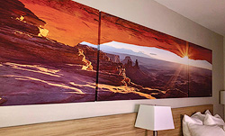 On a recent trip to Tucson, Arizona, I checked into my hotel room and was greeted by a familiar triptych photograph over the bed: Mesa Arch! The Navajo sandstone reds, salmons, golds and buttery yellows were all there, backlit by a sunrise. To see the real thing, you should go to the Mesa Arch Trailhead in Canyonlands National Park. The trail is a 0.6-mile (1-kilometer) roundtrip loop with only about a 50- to 150-foot elevation gain. A “glow up” is a positive transformation in a person’s life, often involving fitness and mental well-being, The Mesa Arch Trail offers some of both.
Altogether, this trailhead is about a 45-minute drive from Moab and 6.3 miles south of the Island in the Sky Visitor Center, accessed once you turn left/east into the Mesa Arch Parking Area. The trail features chunky steps, packed dirt, and slickrock. Going clockwise, about halfway up the trail (0.3 of a mile), is the 27-foot-long pothole arch rock span, named for its setting, perched on a cliff at the eastern edge of Island in the Sky Mesa, part of a 1,200-foot total drop into Buck Canyon. (There is also a short, paved Buck Canyon Overlook trail to a railed-off viewpoint south of Mesa Arch.) Looking down, you can see the White Rim Road and Mountain Bike Trail; beyond, the Colorado River meets the Green River and flows southwest down into and through the Grand Canyon.
On a recent trip to Tucson, Arizona, I checked into my hotel room and was greeted by a familiar triptych photograph over the bed: Mesa Arch! The Navajo sandstone reds, salmons, golds and buttery yellows were all there, backlit by a sunrise. To see the real thing, you should go to the Mesa Arch Trailhead in Canyonlands National Park. The trail is a 0.6-mile (1-kilometer) roundtrip loop with only about a 50- to 150-foot elevation gain. A “glow up” is a positive transformation in a person’s life, often involving fitness and mental well-being, The Mesa Arch Trail offers some of both.
Altogether, this trailhead is about a 45-minute drive from Moab and 6.3 miles south of the Island in the Sky Visitor Center, accessed once you turn left/east into the Mesa Arch Parking Area. The trail features chunky steps, packed dirt, and slickrock. Going clockwise, about halfway up the trail (0.3 of a mile), is the 27-foot-long pothole arch rock span, named for its setting, perched on a cliff at the eastern edge of Island in the Sky Mesa, part of a 1,200-foot total drop into Buck Canyon. (There is also a short, paved Buck Canyon Overlook trail to a railed-off viewpoint south of Mesa Arch.) Looking down, you can see the White Rim Road and Mountain Bike Trail; beyond, the Colorado River meets the Green River and flows southwest down into and through the Grand Canyon.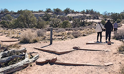
 To avoid the largest crowds, hike this trail several hours after sunrise (as I did) or in the late afternoon. On the morning I was there, visitors were patient, snapping photos, then stepping aside and offering to do photos for other groups. Whichever direction you choose, this may not be an “easy” hike for some. The loop has slightly more elevation change at the beginning if you travel counter-clockwise. To reduce the number of stairs, walk clockwise to the arch, then retrace your steps. The steps are chunky, and some sandstone is covered in loose sand, so trekking poles may come in handy for elderly visitors or those with mobility issues. However you enjoy the Mesa Arch setting—at dawn, after a snowfall, in the fog, at sunset, or even over a hotel room bed—bask in this glowing geological starshine in our amazing national park.