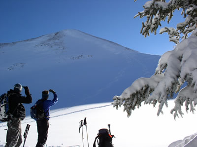
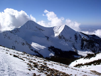
Winter in the La Sal Mountains 2008-09
 When the weather in Moab gets cold, freezing the Colorado River and putting snow and ice on everybody’s favorite bike trail or climbing route, there is another alternative available. Find yourself in an inversion? It is time to go and discover the recreation opportunities in the La Sal Mountains. When the weather in Moab gets cold, freezing the Colorado River and putting snow and ice on everybody’s favorite bike trail or climbing route, there is another alternative available. Find yourself in an inversion? It is time to go and discover the recreation opportunities in the La Sal Mountains.
The La Sals are second only to the Uintas as the highest peaks in the state of Utah. These mountains soar to almost 13,000 feet above sea level and over 8,000 feet above the valley floor. A laccolith process formed the La Sals. With this process, a mass of igneous rock intruded between layers of sedimentary rock, resulting in uplift. You could call them frustrated volcanoes too. Aside from the volcanoes of the Pacific-Northwest, there are no peaks with greater rise in the continental U.S.
Winter recreation in the La Sals includes cross country skiing, skate skiing, snowshoeing, sledding, back-country skiing and snowmobiling. The winter access to the mountains is provided from two routes kept open by the Grand and San Juan County Road Departments.
1. The La Sal Mountain Loop Road is plowed regularly. The Geyser Pass road is kept open to the restrooms and parking area at 9,600’. The snow packed road to the pass and on to Dark Canyon Lake on the other side is a popular area for cross country skiing, snowshoeing and snowmobiling. The road also provides access to backcountry skiing and snowboarding in the Mt. Tomasaki and Gold Basin areas. There is a sledding hill just below the parking lot. If you are using the sledding hill, please park in the parking lot so other vehicles can get to the parking lot. The road in the winter is narrow enough!
Snowmobiles are not allowed to leave the road in Gold Basin. Please respect this closure of the most popular skiing area in the La Sals - the rest of the entire range is open to you!
2. From near Old La Sal at the south end of the range, the road is plowed regularly two miles short of Dark Canyon Lake. The San Juan Road Department makes a parking lot at about 9,600’. If we are fortunate, they plow the road towards La Sal Pass as well, with a parking lot plowed out just before you cross La Sal Creek.
Winter Huts are available for rent from
Tag-A-Long Tours: 259-8946
These simple cabins are great for folks who want to spend several days in the mountains, but don’t want to lose a couple of hours driving back and forth from town every day. The hut operators can snow cat your supplies and camping gear in for you saving you the heavy carry.
Avalanche Hazard
in the La Sal Mountain
The La Sals are rubbly piles of fractured stone.The angle of repose for this broken stone is 38 degrees, and since snow is also a granular substance, 38 degrees is the bulls-eye slope angle for snow avalanches. Keep in mind though, that avalanches run on terrain from 30 - 45 degrees. Most people caught in avalanches are in terrain that is 30 - 35 degrees of steepness.The La Sal Mountains usually possess one of the weakest snow packs imaginable.
Why do we care? Because 30% of people completely buried by avalanches are killed by trauma and many of those remaining die from suffocation. These are not good odds. It’s not good policy to plan on outrunning an avalanche, even on a fast snowmobile, because avalanches have been clocked at well over 200 mph. Grim statistics showing that snowmobilers are the most likely people to be killed in avalanches also support this.
So what do we do? Fortunately, staying safe doesn’t have to mean staying at home! The good news is that most people trigger the slide that catches them, so if we learn a little about snow and adjust our behavior to suit the conditions, we can continue to enjoy our winter playground!
The Manti-La Sal Avalanche Center in Moab exists to help you make the right decisions. The MLSAC Forecasters examine the snow and produce an advisory informing you of where you are most likely to run into problems and just how sensitive the snow is. They also produce a mountain weather forecast, work with the Moab Winter Search and Rescue Team and provide avalanche education to the community in numerous ways. The MLSAC educates the community through the advisories, classes held periodically, radio announcements on the weekends on KZMU, the website and at the Geyser Pass Trailhead information board.
You can access the current advisory by calling 259-SNOW (7669)
or from the Internet at www.avalanche.org/~lsafc
The website is a great tool for:
• Finding a weather forecast for the Moab area, including radar images
• A current photo gallery of the La Sal Mountains
• Advisories for the La Sals and the Manti-Skyline
• A current course schedule for southeast Utah
Watch for periodic special events like ski swaps and avalanche awareness classes. If you need to talk to one of the avalanche forecasters, please call 259-7155 Monday-Friday during normal business hours and be sure to mention you read about it in Moab Happenings.
|